
Two major arrival flight paths cross Culver City and the FAA’s Draft Environmental Assessment proposes changing their heights and positions.
During daytime operations, aircraft arriving from the North and West to LAX follow the conventional flight path SADDE SIX. There will be 3 new satellite based Standard Terminal Arrival Routes (RNAV STAR’s) called CRSHR, IRNMN, HUULL. All 3 arrival routes converge as one path west of Santa Monica so they will follow the same path over Culver City. Two new waypoints have been created and define the path over Culver City: Aircraft fly from CLIFY, near the Santa Monica Airport to DAHJR, near Redondo & Blackwelder east of Culver City.
The daytime path over Culver City is predicted ON AVERAGE to be the same height as current operations. It 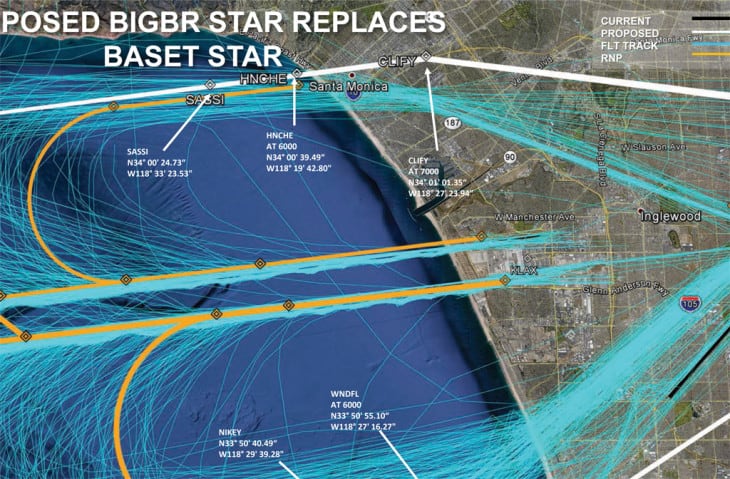 is also slightly North– it enters Culver City at Overland and Venice and exits through Hayden Tract – It flies over the police station instead of Carlson Park. A possible benefit of the new RNAVs is that the aircraft are continuing thier Optimized Profile Descent (OPD) which can potentially delay noise causing landing preparations, such as lowering flaps, until after DAHJR. Previously they exited the RNAV over Santa Monica Airport and started slowing down over Culver City.
Daytime arrivals – HUULL, IRNMN, CRSHR flow from West to East
During nighttime operations, aircraft arriving from the East will overfly Culver City from TOMYS, near Dr Maya Angelou Community High School, and fly over Santa Monica’s CLIFY. This arrival path is the BIGBR STAR and is north of the previous nightime arrival path– It enters Culver City over West LA College and exits east of Tito’s Tacos. This will also be 1000 ft lower. Five % of Culver City’s overflight will be by this route.
Nighttime and East Flow Arrivals – BIGBR
Nighttime and East Flow Arrivals – BIGBR
Below are the 2 arrival paths in a zoomable map. Red is the daytime route from west to east which will carry ~95% of traffic, Black is the nightime east to west.
For an interactive map go to http://bit.ly/1OkRHpN
– Stephen Murray

It looks like I broke the link to the interactive map. try this one: http://bit.ly/1PyROi2 or this: http://doorstoarrival.com/the-culver-city-flight-paths/
Actual flight path widths vary between a 1 nautical mile wide radius for the conventional and RNAV procedures, to 1/3 of a mile radius for newer RNP procedures -which happens east of Culver City after DAHJR. Roughly 36% of the traffic is estimated to follow a precise line.
Mr. Stephen,
After viewing your web-page and maps of airline paths into LAX I was deeply intrigued with how you acquired the data to do so. I am currently working on a research project for university which aims at distinguishing the difference in precision between RNAV approaches from other approaches such as ILS, VOR, or NDB. Your map of LAX (LAX_Proposed_Arrival_Procedures-East_Flow-3-730×479) is nearly identical to the display my group and I are trying to achieve and we would be deeply grateful for aid in doing so. Thank you for your time and consideration.
Respectfully,
Ryley Bendewald